
Unmanned Launch and Recovery System - the future of ocean mapping
Erik T. Sollesnes &
Per Norvald Boge.
Published at: useaoceandata.com
Date: 21.01.22

Autonomous underwater vehicles (AUV) are what make ocean bed mapping possible. They can perform a variety of ocean surveys such as a bathymetry survey of the sea floor or be a basis for planning submarine cables or pipelines. The information provided through ocean mapping will give valuable information on the state of today and changes over time.
The unique technology from USEA Ocean Data
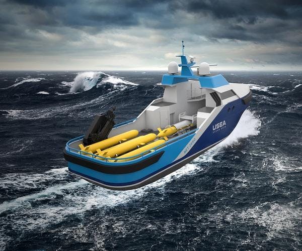
Our AUVs can carry a suite of sensors, from high-altitude low-resolution, to low-altitude high-resolution sensors. Compared to surveys with surface vessels, the resolution of the data is greatly improved due to the AUVs ability to work closer to the data source. Equipped with a Synthetic aperture sonar (SAS) data can be produced with a resolution down to 4x4cm.
Our vehicles use our groundbreaking technology, uLARS (Unmanned Launch and Recovery System), that allows the vessel to be operated completely unmanned. Improved autonomy is enabling the AUVs to perform more tasks with less monitoring and control. Improvements in subsea navigation can enable the AUV to map for longer periods at a time and onboard processing of sensor data will enable the AUV to actively adapt the mission to the observations making the process efficient, targeted, and flexible.
Never a moment's rest
Our AUV technology is under constant development and new application areas emerge with new and existing industries. Our subsea survey sensors are continuously being improved and sized to fit on an AUV platform. For a sensor to be implemented on an AUV platform the size, weight and energy consumption are vital specifications. These are just a few of the aspects we are working tirelessly to improve. We believe that mapping of the ocean is crucial for the future and that it must be done in a considerate, efficient and cost-effective way. That's why we believe that unmanned vessels from USEA Ocean Data is the future of ocean mapping.